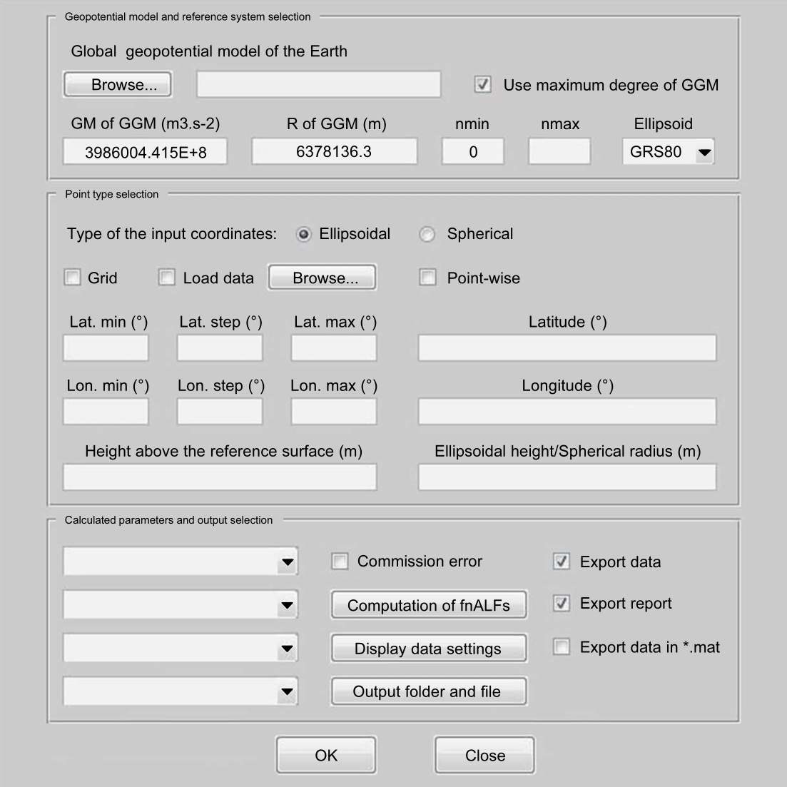
Blažej Bucha is a Lecturer at the Department of Theoretical Geodesy and Geoinformatics , Slovak University of Technology in Bratislava. His research focuses on high-degree spherical harmonic synthesis, gravity field modeling of celestial bodies, and computational geodesy. Developed open-source software packages: GrafLab (gravity field visualization), CHarm (spherical harmonic transforms), and SRBF (regional gravity modeling). Key research areas include planetary geodesy (Moon, asteroid Bennu), divergence-free spherical harmonic expansions , and high-resolution gravitational mapping at scales down to 2 arc-seconds. Highest academic contributions involve ultra-high-degree harmonics (n=21600) and 256-digit precision calculations for resolving divergence effects. His work has applications in geoid determination, gravitational tensor analysis, and geophysical interpretation. Co-authored 15+ peer-reviewed papers in Journal of Geodesy , Geophysical Research Letters , and Computers & Geosciences . Developed grav-sr-2arcsec (Slovak Republic's gravitational maps) and GMSQ2019 (gravimetric quasigeoid at 2" resolution). Teaching activities include co-authoring the textbook Fyzikálna geodézia (2023) and delivering lectures on Physical Geodesy .
Jack Loveless is a Professor of Geosciences at Smith College, specializing in earthquake-related processes using high-precision GPS data to analyze surface motion in tectonically active regions. He compares contemporary deformation with long-term geological records to understand seismic hazards. Education: Ph.D. in Structural Geology from Cornell University (2007) B.S. in Geology from University of New Hampshire (2002) His research spans diverse regions including the Atacama Desert (Chile), southern California, Japan, Tibetan Plateau, and Olympic Peninsula (USA), focusing on faulting, subduction, and stress modeling. Key methodologies include boundary element models, GPS data inversion, and software tools like Blocks and tridisl .
Dr. Takács Bence Géza serves as an Associate Professor at the Department of Geodesy and Surveying within the Faculty of Civil Engineering at Budapest University of Technology and Economics (BME). With over two decades of academic engagement, he maintains active roles in teaching core surveying courses, supervising student research projects (TDK), and leading departmental field practice programs. His institutional responsibilities include serving as the department's TDK coordinator and field practice course supervisor, while maintaining professional affiliations with the Hungarian Academy of Sciences, Hungarian Chamber of Engineers, and Hungarian Society of Surveying. Education: PhD in Earth Sciences, Budapest University of Technology and Economics (2005) MSc Land Surveyor and Geomatics Engineer, Budapest University of Technology and Economics (1999) Dr. Takács specializes in Global Navigation Satellite Systems (GNSS) and Engineering Geodesy with particular expertise in Safety of Life applications, Performance Based Navigation procedures, and infrastructure monitoring systems. His research bridges theoretical geodesy with practical civil engineering challenges, focusing on bridge load testing, road infrastructure quality control, and modernization of cadastral systems through point cloud technologies. Recent work demonstrates strong emphasis on ionospheric modeling for GNSS integrity, EGNOS network deployment, and open-source solutions for coordinate transformations, reflecting his commitment to advancing both academic knowledge and industry standards in geospatial engineering. Analysis of his publication record (2014-2021) reveals a clear trajectory toward practical implementation of geodetic techniques in critical infrastructure projects. His work consistently addresses safety-critical applications in aviation navigation (PBN4HU, BEYOND projects), structural monitoring of bridges (Rákóczi Bridge, Komárom Bridge), and modernization of land registry systems. The integration of machine learning for ionosphere modeling and open-source GIS development highlights his innovative approach to solving complex geospatial problems across civil engineering and transportation domains. Scientific Awards: Academy of Sciences Youth Award (2004) Award for consultation of student research projects, BME (2007) Rector's Award (2021) Hazay Prize (2021) Dr. Takács actively supervises student research through TDK programs and coordinates comprehensive surveying field practice courses. His research leadership spans major projects including PBN4HU (implementing Performance Based Navigation at Hungarian airports), BEYOND (building EGNSS capacity across multimodal domains), and EDCN (operating EGNOS monitoring stations). These initiatives demonstrate significant grant acquisition capabilities with direct applications to aviation safety, road infrastructure monitoring, and national geodetic infrastructure. His work bridges academic research with practical industry implementations through collaborations with the Paksi Nuclear Power Plant, Budapest Metro, and Hungarian road construction authorities. As a key member of the Committee on Geodesy and Geoinformatics at the Hungarian Academy of Sciences and serving on multiple certification committees for the Hungarian Chamber of Engineers, Dr. Takács shapes national standards for geospatial practice. His departmental leadership in surveying field courses and TDK supervision creates pipelines for next-generation geospatial professionals, while his professional qualifications as a certified designer (GD-T) and expert (GD-Sz) in land surveying ensure industry relevance of academic training.
Dr. Magdala Tesauro is a Visiting Professor in the Tectonics Group of the Department of Earth Sciences at Utrecht University . Her research focuses on geophysical modeling of lithospheric and mantle structures, integrating gravity, seismic, geodetic, and geological data to link deep Earth processes with surface dynamics. Key research areas : Geophysics, Tectonics, Lithosphere Modeling, Mantle Dynamics Current collaborations : U.S. Geological Survey (global crustal models) Her work addresses thermal and rheological lithosphere structure , distinguishing mantle compositional vs. thermal effects to understand continental evolution. She contributes to Pathways to Sustainability initiatives, particularly Energy Transition projects. Recent publications include 3D lithospheric models for Australia, Africa, and South America , numerical analyses of seismic attenuation , and cratonic basin dynamics . Her expertise spans global-scale geodynamic modeling and regional tectonic studies in the Tyrrhenian Sea and Congo Basin .
Valérie Ballu is a CNRS Research Director at the University of La Rochelle, affiliated with the DPL team. Her research focuses on underwater and coastal geodesy, utilizing GNSS, altimetry, and tide gauge data to study crustal movements, subduction zones, and sea-level changes. She contributes to interdisciplinary projects addressing coastal hazards and volcanic activity, particularly in Vanuatu, Mayotte, and the Indian Ocean. Research Themes : Vertical and horizontal geodetic positioning, subduction dynamics, and coastal vulnerability. Technologies : PAMELi autonomous drone development for coastal exploration. Her recent work includes monitoring the Mayotte volcanic crisis (2024) and analyzing the Ganges-Brahmaputra-Meghna delta subsidence (2021). She collaborates with geographers, oceanographers, and seismologists, emphasizing interdisciplinary data integration for hazard assessment. Scientific contributions span seafloor deformation studies (2024), calibration of altimetry missions (2023), and modeling of seafloor geodetic positioning (2021). She holds a HDR (Habilitation à Diriger des Recherches) and actively participates in international conferences like EGU and OSTST.
D. Sarah Stamps is a tenured Associate Professor of Geophysics at the Virginia Tech Department of Geosciences within the College of Science. Her research integrates millimeter-precision GNSS/GPS measurements with high-performance computational modeling to study geophysical processes in active tectonic regions. Education: Ph.D., Geophysics/Geodesy, Purdue University (2013) B.Sc., Earth Sciences and Mathematics minor, The University of Memphis (2007) Her work focuses on continental rifting mechanisms , volcano-tectonic interactions , and mantle-lithosphere dynamics , with applications to seismic and volcanic hazards. Recent studies explore melt generation in magma-poor rifts, modern geodetic data processing frameworks, and coastal vertical land motion quantification. Scientific Awards NSF CAREER Award (2020-present) NSF Computational Infrastructure for Geodynamics Distinguished Lecturer (2017-2020) NSF EarthCube Community Service and Leadership Award (2017) NSF Postdoctoral Research Fellowship (2013) NSF Graduate Research Fellowship (2009) She leads the Geodesy and Tectonophysics Laboratory (www.geodesy.geos.vt.edu) and contributes to geoscience modernization initiatives, including cyberinfrastructure development and capacity-building in developing countries.
Jonathan Li is a full professor at the University of Waterloo, holding dual appointments in the Department of Geography and Environmental Management and the Department of Systems Design Engineering. His expertise lies in geospatial data science and artificial intelligence, focusing on urban remote sensing, LiDAR point cloud processing, and applications in digital twin cities and autonomous vehicles. He leads research in GeoAI for multi-scale mapping, 3D urban modeling, and environmental monitoring. Dr. Li is a Fellow of multiple prestigious institutions including IEEE, Royal Society of Canada, and Canadian Academy of Engineering. He currently serves as President of the Canadian Institute of Geomatics (CIG) and Editor-in-Chief of the International Journal of Applied Earth Observation and Geoinformation (JAG). His work bridges academic research with practical applications in infrastructure inspection, disaster management, and geospatial software development. Research Interests: Urban remote sensing using multispectral, hyperspectral, and LiDAR data; machine learning for geospatial analysis; GeoAI for environmental monitoring; 3D object detection in mobile mapping systems. His lab focuses on developing innovative software tools for HD mapping and geospatial data analysis. Recent Publications: Over 50 articles in journals like Remote Sensing of Environment, IEEE Transactions on Geoscience and Remote Sensing, and ISPRS Journal of Photogrammetry. Awards: Multiple fellowships and editorial roles reflect his leadership in geomatics and remote sensing. Grants: Extensive funding for research in AI-driven geospatial solutions. Lab Activities: Prof. Li's research group collaborates with industry on projects involving autonomous vehicle mapping, urban flood modeling, and smart city infrastructure. Their work emphasizes cross-disciplinary collaboration between geomatics, computer science, and civil engineering.
Richard Waldron Allmendinger is a Professor of Structural Geology at Cornell University's College of Engineering and a visiting professor at the Universidad Católica del Norte, Chile. He specializes in understanding brittle upper crustal deformation during earthquakes and long-term tectonic processes in South America. His research spans structural geology, tectonics, and geophysics, with a focus on seismic reflection profiling, numerical modeling, and field geology. Allmendinger earned his A.B. from Cornell (1975) and Ph.D. from Stanford (1979), followed by postdoctoral work with COCORP. He served as Cornell's Associate Dean for Diversity (2008–2011) and remains active in mentoring underrepresented students through the Sloan Faculty program. His software tools, such as Stereonet and SSPX, are widely used in the field. He has received multiple awards, including the 2012 Career Contribution Award from the Geological Society of America and teaching accolades from Cornell Engineering. Education: A.B., Geological Sciences, Cornell University (1975) Ph.D., Structural Geology, Stanford University (1979) Research Interests: His work integrates field studies, geophysical data, and computational models to explore tectonic processes in regions like the Andes and the North American Cordillera. Key themes include forearc deformation, earthquake mechanics, and the interplay between structural geology and geodesy. Recent projects focus on the 2014 Pisagua earthquake and the application of lidar and geothermal energy solutions. Publications: Allmendinger’s recent work emphasizes computational field geology, geothermal energy applications, and tectonic processes in Chile and the U.S. Northeast. His 2023 studies on transpression in mineral districts and lidar-based terrain analysis highlight innovations in both field and analytical methods. Awards & Honors: Presidential Award for Excellence in Science Mentoring (NSF, 2011) Robert Cowie Excellence in Teaching Award (2009) Zellman Warhaft Diversity Award (2013) Teaching & Service: Known for innovative teaching methods, Allmendinger eschews PowerPoint while embracing interactive tools like i-Clickers. He advocates for energy sustainability and climate change awareness through public lectures and the Atkinson Center for a Sustainable Future. His mentorship extends to diversity initiatives in engineering education. Labs/Teams: Leads software development for structural geology tools and collaborates with the Cornell Geothermal Program. His work bridges academia and industry via seismic data reprocessing and educational software distribution.
Sonia Cafieri is a Professor at the École Nationale de l'Aviation Civile (ENAC) in Toulouse, part of the Université de Toulouse. She leads the Mathematics of Optimization and Operations Research (MORO) group within the OPTIM research team. Her roles include membership in the Managing Board of EUROPT and the Nonlinear Mathematical Programming group of GdR-ROD. She chairs the Program Committee of EUROPT 2021 and serves on ENAC's Research and Doctoral Councils. Education: HDR in Applied Mathematics (2012, Université Paul Sabatier), PhD (2006, University of Naples), and Laurea in Mathematics (2001, Second University of Naples). Research focuses on Nonlinear Optimization, Global Optimization, Combinatorial Optimization (network clustering), and Operations Research applications in air transportation and engineering. Recent work addresses air traffic management, trajectory optimization, and stochastic programming for robust scheduling. Publications span optimization methodologies and applications, with a focus on aircraft conflict resolution, drone trajectory planning, and robust cyclic scheduling. Software contributions include ROSE (reformulation engine) and COUENNE (MINLP solver). Teaching includes courses on Numerical Analysis, Combinatorial Optimization, and Operations Research for Air Transportation at ENAC and other institutions.
Dr. Ahmed Abdalla is an Assistant Professor in the Department of Civil & Environmental Engineering at Louisiana State University (LSU), affiliated with the Center for Geoinformatics. He holds a PhD in Surveying from the University of Otago, New Zealand, and has held academic positions at institutions in Sudan, Germany, and Sweden. His research focuses on geodesy, geoinformatics, and remote sensing applications in environmental monitoring, with specialties in geoid modeling, land subsidence analysis, and gravity field studies. He has extensive experience in GNSS, InSAR, and satellite gravimetry technologies. Education: PhD in Surveying, University of Otago, New Zealand (2013) MSc in Geodesy and Geoinformatics, Royal Institute of Technology, Sweden (2009) BSc in Surveying Engineering, University of Khartoum, Sudan (2003) Research Interests: Geoid and gravity field modeling Land subsidence monitoring using GNSS/InSAR Remote sensing for environmental applications GIS integration with geophysical datasets His recent work emphasizes coastal Louisiana subsidence analysis, Sudan gravity field development, and machine learning enhancements for geodetic measurements. Over 50 peer-reviewed publications demonstrate his contributions to geospatial science and engineering. Professional Experience: 2018-Present: Assistant Professor, LSU 2014-2018: Assistant Professor, University of Khartoum 2017-2018: Visiting Scientist, Leibniz University of Hanover Labs/Teams: Active member of LSU's Center for Geoinformatics, leading geospatial research initiatives in environmental monitoring and geodetic infrastructure development.
Dr. Jessica Mejia is an Assistant Professor of Cryosphere and Polar Sciences in the Department of Earth and Environmental Sciences at Syracuse University. With formal training in Glaciology and Hydrogeology, she leads field campaigns on Greenland's Helheim Glacier and develops open-source data analytics software for cryospheric research. Ph.D., Geology, University of South Florida (2021) M.S., Geophysics, University of Alaska Fairbanks (2016) B.S., Mathematics & Physics, Texas A&M University Commerce (2014) Her research focuses on glacial hydrology , particularly hydro-dynamic coupling on ice sheets, combining field observations, remote sensing, and computational modeling. Current projects investigate firn aquifer hydrology , subglacial drainage systems , and ice fracture mechanics through interdisciplinary approaches. Recent publications highlight her work on crevasse propagation , moulin dynamics , and ice viscosity effects on meltwater drainage. She has received recognition including a Highlight paper in The Cryosphere (2024). Founded CryoCommunity.org, a DEI resource hub for cryospheric sciences Core developer of CryoCommunity Coordinator of the International Firn Workshop Dr. Mejia's work bridges glacial hydrology , ice dynamics , and climate impact studies , with particular emphasis on Greenland Ice Sheet processes affecting global sea level rise.
Amirhossein Bagheri is a planetary geophysicist currently serving as a Postdoctoral Scholar Research Associate at the Seismological Laboratory of the California Institute of Technology (Caltech), collaborating with Prof. Mark Simons and NASA Jet Propulsion Laboratory. His research focuses on planetary interior structure and evolution through geodetic, tidal, and seismic analyses. PhD in Planetary Geophysics from ETH Zurich MSc and BSc in Civil Engineering from Sharif University of Technology His research employs numerical methods, inversion techniques, and orbital dynamics to study habitability and interior properties of planetary bodies, particularly icy moons (Enceladus, Europa, Pluto-Charon) and Mars' satellites. Recent work includes modeling Enceladus' subsurface ocean using geodetic data and investigating tidal-thermal evolution across multiple planetary systems. Scientific publications span tidal dynamics , interior modeling , and seismic wave propagation in complex media. Collaborations include institutions like UC Berkeley, NASA JPL, and ETH Zurich.
Eric O. Lindsey is an Assistant Professor at the University of New Mexico's Department of Earth and Planetary Sciences within the College of Arts and Sciences. His research focuses on geodetic measurements of Earth's surface deformation using GPS/GNSS and InSAR technologies, particularly in active tectonic and volcanic regions. Lindsey explores tectonic processes, earthquake mechanics, and human-induced land changes, with field projects in Myanmar, Indonesia, Costa Rica, and the U.S. Southwest. He earned his Ph.D. in Geophysics from UC San Diego (2015) and has conducted postdoctoral research including a Fulbright-Nehru fellowship. His work includes advancing InSAR processing techniques, collecting seafloor geodetic data offshore Central America, and developing numerical models of fault behavior. Key research interests: geodesy applications in tectonics, megathrust coupling analysis, anthropogenic land subsidence, and earthquake/volcanic hazard assessment. Current projects involve dense GNSS networks in Myanmar, submarine GNSS installations in the Middle American Trench, and InSAR-based land deformation mapping in coastal cities. Recent studies highlight discoveries like 32-year slow-slip events preceding Sumatran earthquakes and subsidence-driven sea-level rise in major cities. Lindsey mentors students through UNM's E&PS graduate programs, emphasizing fieldwork and computational geophysics training.
Dr.-Ing. Jan Kodet is a researcher at the Geodetic Observatory Wettzell, affiliated with the Technical University of Munich (TUM), specifically within the Engineering Institute for Astronomical and Physical Geodesy. His work centers on advanced instrumentation and measurement techniques in space geodesy, including satellite laser ranging, VLBI, and ring laser interferometry for monitoring Earth's rotation. University: Technical University of Munich Research Institute: Engineering Institute for Astronomical and Physical Geodesy Observatory: Geodetic Observatory Wettzell Email: jan.kodet@tum.de His research interests span space geodesy, ring laser interferometry, time and frequency transfer, satellite tracking, and geodetic instrumentation. He develops high-precision systems for optical timing, photon counting, and co-location of geodetic techniques. His work contributes to global geodetic reference systems and fundamental metrology. The recent publications highlight a strong focus on measuring Earth's rotation using large ring lasers (e.g., ROMY), developing optical event timers for satellite ranging, and advancing VLBI techniques for satellite tracking. There is a clear trend toward integrating multiple geodetic techniques and achieving sub-picosecond timing precision for improved geodetic accuracy. Dr. Kodet has supervised master’s students, including Hanna, Maria (2022) on clock comparisons using event timers and Wong, Siow Kay (2018) on atomic clock synchronization via GNSS. His collaborative research involves institutions and projects like ESA, DFG (NEROGRAV, UPLIFT), and international geodetic networks. He is a key contributor to projects involving the Wettzell observatory, such as VGOS and fundamental station development. His work is supported by involvement in major research initiatives including the DFG Research Unit NEROGRAV and the DFG Research Training Group UPLIFT, indicating active grant funding and participation in structured research programs.
Slavko Vasiljević is an Associate Professor at the Faculty of Architecture, Civil Engineering and Geodesy of the University of Banja Luka. Specializing in geodesy and geomatics, his work focuses on structural monitoring, GIS applications, cadastral systems, and geodetic network design. He has contributed to projects such as the establishment of the Republic of Srpska’s vertical reference framework and the geodetic monitoring of the Bočac Dam. His research spans geospatial data analysis, structural deformation measurement, and flood modeling. Notable work includes enhancing digital image quality using MATLAB and developing GIS models for population census analysis. He actively participates in international conferences, presenting on topics like geodetic control systems for high structures and spatial data paradigms. Projects: Led and collaborated on projects involving architectural heritage documentation, mineral detection in agriculture via remote sensing, and academic excellence in geoinformatics. Awards: Received the First Prize in the category of environmental protection and landscape architecture for the Arboretum project in Banja Luka. His interdisciplinary work bridges geodesy with civil engineering, environmental science, and urban planning, contributing to infrastructure development and disaster management strategies.