
معرفی
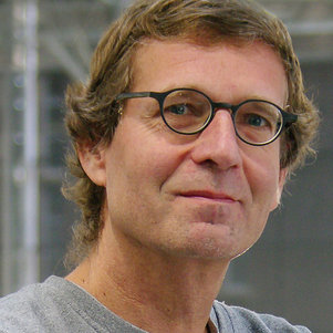
Prof.dr.ir. P.J.M. van Oosterom is a Professor of GIS Technology at the Faculty of Architecture and the Built Environment, Delft University of Technology. His research focuses on spatial information infrastructure, emphasizing durable geo-data sharing and reuse through standardized datasets and services. Key projects include the Varioscale geo-information concept and Massive Point Clouds, leveraging eScience techniques. He co-developed the ISO 19152 land administration domain model with the Dutch cadastre. Van Oosterom holds patents in geospatial innovation and chairs the International Federation of Surveyors (FIG) Working Group on 3D Cadastre. He is Scientific Director of the Wuhan University-TU Delft Joint Research Centre on Spatial Information.
Research Interests: Spatial data infrastructure, 3D geometry validation, vario-scale modeling, real-time GIS applications, and geoinformation policy. His work integrates technology development with societal impact, such as contributions to Oracle Spatial databases and global standards.
- Awards: Oracle Spatial Award, Dutch Geo-Innovation, and patents in localization and geo-information scaling.
- Leadership: Editorial board member of multiple journals and conference program committees.
Projects: Varioscale data structures, 3D cadastre models, and international collaborations in geospatial innovation.
P.J.M. van Oosterom در سایتهای دیگر
جستوجوهای مرتبط
شاید اینها هم برایتان مناسب باشند
- GGheorghe M. BadeaTechnical University of Civil Engineering Bucharest · استاد
- AAndre Da Silva ManoUniversity of Twente · مدرس
 Mila N. KoevaUniversity of Twente · دانشیار
 Anca ENETechnical University of Civil Engineering Bucharest · استادیار
- TTahsin YomralıoğluIstanbul Technical University · استاد
- GGheorghe BadeaTechnical University of Civil Engineering Bucharest · استاد