
معرفی
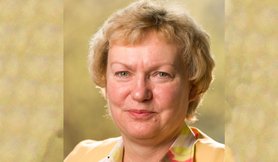
Prof. Dr.-Ing. Martina Müller is a Professor at the Faculty of Spatial Information, specializing in Computer-Aided Cartography. Her teaching focuses on map design, coordinate reference systems, geospatial data visualization, and geoprocessing. She is actively involved in the development and application of 3D city and terrain models, including subterranean spaces.
Her research emphasizes modeling and visualizing 3D urban and terrain environments, with a particular interest in underground building areas. She has contributed to the joint commission on "3D city models" since its formation in 2009, collaborating with the German Society for Cartography and Geomatics (DGfK) and the German Society for Photogrammetry, Remote Sensing, and Geoinformation (DGPF).
In her teaching, she offers modules such as:
- G612 - 3D Modelling (Geomatics study program, 6th semester)
- G626 - Geoprocessing (4th semester, Cartography specialization)
- G631 - Cartographic Project (6th semester, Cartography reinforcement)
- G648 - Coordinate Reference Systems (2nd semester)
- G359 - Coordinate Reference Systems (1st semester, Geoinformatics/Management)
- G384 - 3D City Models (2nd semester, Geoinformatics/Management)
- G386 - Cartography and Geoprocessing (2nd semester, Geoinformatics/Management)
- G850 - Cartography (2nd semester, Surveying study program)
- G860 - Data Presentation/Multimedia (9th semester, Surveying study program)
Martina Müller در سایتهای دیگر
جستوجوهای مرتبط
شاید اینها هم برایتان مناسب باشند
- MMartina Di RitaPolytechnic University of Turin · دانشیار
 Renate RudatDresden University of Applied Sciences · مدرس
 Tim PidunDresden University of Applied Sciences · استاد
 Rejane Rienaldi-MielitzDresden University of Applied Sciences · مدرس
 Melanie EliasDresden University of Applied Sciences · استاد
- JJens SchönherrDresden University of Applied Sciences · استاد