Hao Liu is a researcher affiliated with institutions like Chinese Academy of Sciences , Beihang University , and Stanford University . His work spans Computer Science , Artificial Intelligence , and Robotics . Key affiliations: National Space Science Center (Beijing), School of Astronautics (Beihang), Key Laboratory of Pervasive Computing (Tsinghua) Research interests include Machine Learning , Image Processing , Graph Neural Networks , and Wireless Communication Optimization His recent publications focus on: Advanced control systems for fuzzy models Medical imaging via hyperspectral analysis Transformer-based approaches in NLP and vision Quantum-safe and edge computing protocols
Marta Severo is a Lecturer at University of Paris Nanterre in the Department of Information, Communication, Digital Media within the Faculty of Humanities and Social Sciences. She also maintains significant research affiliations with University of Lille where she has directed multiple projects including the PEPS Digital Routes Project (2015-2016). Her academic profile is characterized by interdisciplinary research at the intersection of digital technologies and cultural heritage. Her research focuses on digital representations of cultural heritage, particularly intangible cultural heritage (ICH) and cultural itineraries like the Via Francigena. She investigates how digital methods can be used to study, represent, and safeguard cultural heritage through social media analysis, network mapping, and participatory platforms. Her work examines the relationship between amateurs and institutions in knowledge production, with special attention to Wikipedia as a citizen science tool. Her publication portfolio demonstrates consistent scholarly output with significant contributions to understanding digital representations of cultural routes, stakeholder networks along heritage paths, and participatory approaches to cultural heritage management. Her research shows a clear trajectory from methodological development in digital humanities to applied studies of specific heritage contexts. Humboldt Research Fellowship for Experienced Researchers (2023-2025) for project on ethics of digital participation IUF project funding for 'Data in action' research on research trajectories of implication NEST project (Marie Skłodowska-Curie RISE Action Programme) visiting fellowship at UC Berkeley (2022) As a research leader, Marta Severo has directed multiple significant projects including the ANR COLLABORA project (construction of an observatory of cultural contributory devices), the Wikipatrimoine project (exploring collaborative management of cultural heritage), and the ICH Observatory project (mapping digital networks of ICH stakeholders in France). Her work demonstrates strong commitment to interdisciplinary collaboration across computer science, social sciences, and heritage management. She frequently partners with European institutions including the European Association of Via Francigena Routes and has presented at numerous international conferences on cultural heritage and digital methods.
Philipp Otto is a Professor of Statistics and Data Science at the University of Glasgow. Previously, he was a Reader in Statistics and Data Analytics (2023–2024) and held a Junior Professorship in Big Geospatial Data at Leibniz University Hannover (2018–2023). He earned his PhD in Statistics (summa cum laude) from European University Viadrina in 2016 and a B.Sc. in International Economics, with study visits to Saint Petersburg State University. His research focuses on spatial and spatiotemporal statistics, environmetrics, network modeling, and machine learning applications. Education: PhD in Statistics (2016), European University Viadrina, Frankfurt (Oder) B.Sc. in International Economics (with study visits to Saint Petersburg) Research Interests: Philipp’s work centers on spatial statistics, spatiotemporal volatility modeling, environmental data analysis, and network processes. He develops statistical methods for geo-referenced and network data, with applications in climatology, finance, and environmental risk assessment. His contributions include advancements in GARCH models, spatiotemporal clustering detection, and statistical process monitoring for AI systems. Grants & Projects: He has secured €1,038,847 in research grants, leading projects on historical map time series analysis, agricultural air quality impacts, and high-dimensional spatial dependence structures. Industry collaborations include survival analysis for building information models. Awards: 2017 Fellowship to attend the Lindau Nobel Laureate Meeting (Economic Sciences) 2017 Best Presentation Award (Data Science, Statistics, and Visualisation) Teaching: He teaches statistics and data science across disciplines, including economics, engineering, and mathematics, at both undergraduate and postgraduate levels. Professional Activities: Editorial Boards: Environmetrics (2021), AStA Advances in Statistical Analysis (2020) Member of German Statistical Society (Treasurer, 2013)
Prof. Gerhard Jäger holds the Chair of General Linguistics at the Faculty of Humanities, University of Tübingen . He serves as a Principal Investigator (PI) in the Clusters of Excellence Human Origins and Machine Learning for Science , and leads projects like Phylomilia (funded by Volkswagen Foundation) and CrossLingference (ERC Advanced Grant). His career spans multiple institutions, including Bielefeld University (2004-2009) and Stanford University (visiting scholar, 2004). Habilitation (2002) at Humboldt University Berlin with thesis on Anaphora and Type Logical Grammar PhD (1996) at Humboldt University Berlin on Dynamic Semantics His research bridges computational linguistics , phylogenetic analysis , and game theory , focusing on Bayesian models , language evolution , and cross-linguistic typology . Recent work explores phylogenetic inference from acoustic speech data and geographic influences on language trees . Key contributions include 15+ recent publications on topics spanning phylogenetic typology , cognate detection , and Bayesian language modeling . These works employ machine learning , statistical inference , and evolutionary game theory to analyze language change , typological variation , and linguistic stability . Honors include ERC Advanced Grant , Volkswagen Foundation funding , and DFG-Humanities Centre for Advanced Studies participation. He has taught courses in Computational Historical Linguistics , Phylogenetic Methods , and Bayesian Data Analysis across institutions like Tübingen, Bielefeld, and Stanford. He actively contributes to academic communities through workshop organization (e.g., Quantitative Theoretical Linguistics , Game Theory in Pragmatics ) and serves on the faculty council at Tübingen. His team collaborates with institutions like Max Planck Institute for Evolutionary Anthropology , University of Pennsylvania , and LMU Munich .
Stefan Riezler is a full professor of Statistical Natural Language Processing at Heidelberg University's Department of Computational Linguistics (since 2010), affiliated with the Faculty of Mathematics and Computer Science. Prior to this, he worked in Silicon Valley at Xerox PARC and Google Research. He holds a PhD in Computational Linguistics from the University of Tübingen (1998) and conducted postdoctoral research at Brown University (1999). His research spans machine learning, NLP, and medical informatics, focusing on interactive statistical learning. He co-leads the Interdisciplinary Center for Scientific Computing (IWR) and serves on the editorial boards of Computational Linguistics and Transactions of the Association for Computational Linguistics . Key research areas include neural machine translation, healthcare AI (e.g., sepsis prediction), data augmentation, and reproducibility in ML. He develops tools like JoeyNMT and explores ethical challenges in clinical machine learning. Notable recent work includes advancements in time series analysis, multimodal interfaces (e.g., NLMaps for OpenStreetMap), and ethical frameworks addressing validity in healthcare ML. His publications emphasize practical applications of NLP in healthcare, speech translation, and cross-lingual systems. Grants and collaborations include interdisciplinary projects on medical data science and training next-gen NLP researchers. He actively contributes to open-source toolkits and reproducible research practices.
Johannes Schöning is a Professor of Human-Computer Interaction (HCI) at the University of St. Gallen and leads the Ubiquitous Media Technology Lab . His research focuses on developing user interfaces that empower individuals and communities through data-driven decision-making, with interdisciplinary applications in geographic information science, public health, medical contexts, and extreme environments like space missions. He emphasizes methodological rigor from AI, computer graphics, and cognitive psychology. Organizes AlpCHI 2026 Chair of ACM Eugene Lawler Award Committee Editorial Board, AI Perspectives (Springer Nature) Research Trends : His publications from 2025–2024 reveal a focus on Mixed Reality (autoethnography, weight perception), Accessibility (visual impairment support), Environmental HCI (CO2 eco-feedback), and Geospatial Technologies (navigation externalities, map analytics). Interdisciplinary work appears in journals like Nature and PLOS ONE . Scientific Recognition : ACM Distinguished Member Best Paper & Accessibility Awards (Interact 2019, MobileHCI 2015) Junior Fellow, Gesellschaft für Informatik (2013) Academic Service : Active in conference leadership (SIGCHI Switzerland Chair 2021–2023, ISS 2016 Program Chair) and reviewing for top venues including ACM CHI , Ubicomp , and IEEE VR . Regular reviewer for European science foundations and DFG/BMBF proposals.
Dr. Raimon Tolosana Delgado is a Research Fellow at the Helmholtz-Zentrum Dresden-Rossendorf (HZDR), affiliated with the Helmholtz Institute Freiberg for Resource Technology. He leads research in predictive geometallurgy and statistical analysis of mineral resources, focusing on translating geological data into processing insights. His research integrates geostatistics , compositional data analysis (CoDa) , and machine learning to model ore behavior and resource potential. Key areas include: Predictive geometallurgy for forecasting ore/waste behavior Bayesian statistics for parameter estimation and uncertainty analysis Development of R-based tools (e.g., compositions and gmGeostats packages) for mineral data analysis Particle-based process modelling for mineral separation optimization Recent publications emphasize machine learning integration (e.g., neural networks for geophysical tensor fields), tailings reprocessing (3D geostatistical assessment of resource potential), and advanced statistical methods for compositional data. A consistent trend involves enhancing predictive accuracy in mineral processing through multi-source data fusion. Dr. Tolosana Delgado coordinates the development of technology platforms for geometallurgical data analysis, including databases and interfaces for industrial applications. His work bridges ore geology, mineral processing, and metallurgy to optimize resource efficiency.
Patrick Henkel is a Professor at the Technical University of Munich (TUM) affiliated with the TUM School of Engineering and Design and the Chair of Communication and Navigation. He holds a professorship in Satellite Geodesy under Prof. Hugentobler. His research focuses on advanced positioning technologies, including Global Navigation Satellite Systems (GNSS), autonomous systems, and sensor fusion. He develops algorithms for precise positioning in challenging environments such as urban areas, alpine regions, and indoor spaces. His work also extends to environmental applications, such as snow hydrology and climate monitoring using GNSS signals. Henkel’s contributions include innovations in real-time kinematic (RTK) positioning, UAV navigation, and multi-sensor integration for robotics and autonomous vehicles. His research is supported by collaborations with industry and academic partners, addressing both theoretical and applied challenges in geodesy and navigation. Henkel leads projects on GNSS signal processing, satellite-based environmental monitoring, and autonomous driving technologies. He has contributed to the Galileo HAS service and developed methodologies for snow water equivalent estimation using multi-frequency GNSS signals. His expertise spans hardware-software co-design for navigation systems and algorithm optimization for high-precision positioning in dynamic environments. He actively publishes in top-tier journals and conferences, with a focus on advancing the reliability and accuracy of navigation systems across various domains. His advising and grants include funding for projects on sensor fusion, UAV-based measurements, and satellite receiver development. He collaborates with teams at TUM’s Navigation Lab and the Professur für Satellitengeodäsie, contributing to both academic and industrial applications. His work on low-bandwidth RTK dissemination and laser-tracker verified UAV positioning highlights his commitment to bridging theoretical advancements with real-world implementation.
Prof. Liqiu Meng serves as Chair of Cartography and Visual Analytics at the Technical University of Munich (TUM). He specializes in advanced geospatial research, digital cartography, and human-technology collaboration frameworks. Current Faculty at TUM Chair of Cartography and Visual Analytics Research Focus: His work bridges cartographic theory with cutting-edge technology, covering topics like 3D urban modeling, AI ethics visualization, geovisual analytics, and spatiotemporal data interpretation. Urban Morphology Analysis AI Ethics Cartography Geovisual Analytics 3D City Data Integration Location-Based Service Design Publications: Recent works (2025-2024) demonstrate expertise in explainable AI for urban analysis, multi-agent systems for geospatial interaction, and advanced spatial modeling techniques. Contact: liqiu.meng@tum.de | contact.lfk@ed.tum.de
Krisztina Kis-Katos serves as Professor for International Economic Policy at the University of Göttingen's Department of Economics, a position she assumed in 2016. She holds prominent leadership roles including Chairwoman of the Standing Field Committee of Development Economics of the German Economic Association (Verein für Socialpolitik) and Chairwoman of the Scientific Advisory Board of the RWI Leibniz Institute for Economic Research. Her institutional affiliations extend to research fellowships at IZA and RWI, along with editorial positions at the Journal of Labour Market Research, European Journal of Political Economy, Bulletin of Indonesian Economic Studies, and Journal of Development Studies. Professor Kis-Katos earned her Economics education in Szeged and Konstanz, attended the Swiss Doctoral Program at the Study Center Gerzensee, and received her doctoral degree from the University of Freiburg in 2010. Her scholarly work spans applied development economics and political economy with particular focus on how (de-)globalization and macroeconomic processes affect social and economic outcomes including labor markets, firm performance, land use change, deforestation, and conflict. Her research portfolio reveals consistent thematic threads across recent publications: the intersection of environmental concerns with economic development (particularly deforestation and palm oil in Indonesia), the gendered impacts of trade liberalization, the socioeconomic effects of pandemics like COVID-19, and the complex relationship between governance, corruption, and economic outcomes. Methodologically, her work combines rigorous econometric approaches with innovative data sources including satellite imagery and high-frequency power usage data. Teaching prize for the best doctoral course in RTG 1723, University of Göttingen (2019) Teaching prize of the Student Union of Economics of the University of Freiburg (2014) BMZ/GIZ Public Policy Award (2013) Friedrich-August-von-Hayek-award (2011) Excellence award of the KfW Development Bank (2011) Professor Kis-Katos leads multiple significant research initiatives including the BMZ-DEval funded evaluation of Madagascar's forest restoration program, the DFG-funded Thailand-Vietnam Socioeconomic Panel, and the DFG Research Training Group on Sustainable Food Systems. Her advisory role extends to supervising doctoral candidates through these projects and previously serving as spokesperson for the Research Training Group 1723 on Globalization and Development. Her substantial grant portfolio demonstrates strong research leadership across international collaborations involving institutions in Germany, Indonesia, Thailand, Vietnam, and the United States. Her work connects closely with the Collaborative Research Centre 990 on Ecological and Socioeconomic Functions of Tropical Lowland Rainforest Transformation Systems in Sumatra, Indonesia, reflecting her deep engagement with environmental-economic research questions in Southeast Asia. She also contributes to interdisciplinary teams through projects like PlanetHealth examining global land-use impacts of the COVID-19 pandemic.
Prof. Dr. Hannes Taubenböck holds the Chair of Global Urbanization and Remote Sensing at the Julius-Maximilians University of Würzburg (Faculty of Philosophy, Institute of Geography and Geology) since 2022 and collaborates with the German Aerospace Center (DLR). His research bridges remote sensing with urban geography, focusing on: Global urbanization patterns and structural analysis Informal settlements (slums/refugee camps) Climate change and natural hazard vulnerability Migration dynamics via remote sensing and social media He obtained his PhD (2008) and habilitation (2019) at JMU Würzburg, preceded by geography studies at LMU Munich (1999-2004). His recent publications analyze: Climate impacts on African agriculture Urban permeability and walkability Border region disparities Heat exposure modeling Methodologically, he specializes in: Deep learning for earth observation Multi-modal data fusion Urban pattern classification Building stock analysis His work informs policy applications in: EU cohesion programs Disaster risk reduction Environmental justice Urban sustainability
Meghan Kelly is an assistant professor in the Department of Geography and the Environment at Syracuse University, where she works at the intersection of cartography, feminist theory, and digital storytelling. Previously a doctoral student and instructor at the University of Wisconsin-Madison, she has also taught at Durham University. Her academic career bridges rigorous scholarly research with professional mapmaking for major publications including the Chicago Tribune, Washington Post, Rolling Stone Magazine, and Science Magazine. Kelly's research centers on the role of power in spatial data, map design, and mapping processes, with particular focus on how alternative perspectives can expand conventional cartographic tools. Her recent work examines satellite data usage through a Black feminist lens, while earlier projects investigated Syrian refugee border crossings using feminist methodologies. She approaches cartography as both science and critical practice, consistently challenging traditional representations of space and power. Her publication history shows a clear trajectory from doctoral research on Syrian refugee experiences toward leadership in feminist geographical practice, with increasing emphasis on collaborative, community-engaged mapping approaches. Kelly's work demonstrates how cartography can serve as a tool for social justice when informed by critical theory and diverse perspectives. University-wide Teaching Fellow Award for classroom innovation (2018) Runner up in Map Book and Atlas Category (2015 WLIA) Student Dynamic Map Award Winner (Group) NACIS Runner-Up, David Woodward Award CaGIS Outstanding Thesis Award (2016) Kelly has developed innovative teaching materials across the cartography curriculum, from introductory GIS courses to advanced web cartography. Her teaching philosophy integrates feminist pedagogies with critical approaches to mapping, emphasizing both technical skills and ethical considerations in spatial representation. She has created comprehensive course materials for Geography 170 (Our Digital Globe), Geography 370 (Introduction to Cartography), and Geography 572 (Graphic Design in Cartography), with particular focus on bridging theory and practice in map design. Her collaborative projects, including the Eritrean Human Trafficking Project and Collectively Mapping Borders initiative, demonstrate her commitment to participatory approaches that center marginalized voices in cartographic production. These projects often involve community engagement and alternative visualization techniques to represent complex spatial experiences that conventional maps might overlook.
Maxim Romanov heads 'The Evolution of Islamic Societies' project at University of Hamburg's Asia-Africa-Institut, funded by DFG's Emmy Noether Program. Former positions include senior research fellow at KITAB Project and University of Vienna. Research reconstructs social history of Islamic world (c.600-1600 CE) through computational analysis of Arabic chronicles and biographical collections. Research Focus: Digital humanities approaches to premodern Islamic history including OCR development for Arabic manuscripts, corpus linguistics, and geospatial modeling of historical data. Technical Contributions: Developed OpenITI corpus infrastructure, al-Ṯurayyā gazetteer system, and computational methods for large-scale historical text analysis. Recent work enhances NLP for classical Arabic with OCR accuracy exceeding 90%.
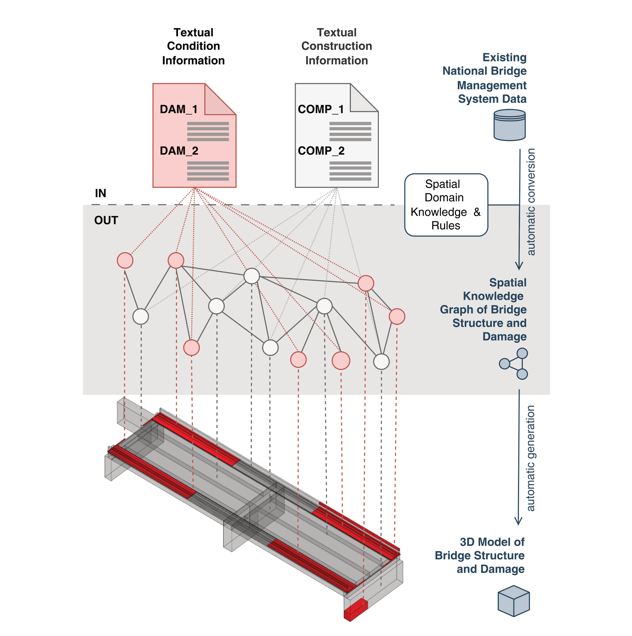
Prof. Dr. Jakob Beetz serves as a University Professor at RWTH Aachen University's Faculty of Architecture, leading the Design Computation (DC) research group. His work addresses critical challenges in sustainable built environments through digital innovation, focusing on integrating knowledge, information, and data across disciplines to reduce the sector's energy and material consumption—which accounts for over one-third of global totals—while advancing climate goals under the European Green Deal. His research spans Building Information Modeling (BIM), digital twins, and artificial intelligence, with emphasis on graph-based data federation, semantic web technologies, and large language models in construction. Key interests include evidence-based planning, parametric design optimization, building physics simulation, and networked knowledge modeling. Recent projects explore federated digital twin ecosystems for infrastructure management, intelligent damage assessment systems, and AI-driven solutions for wood structure preservation, directly contributing to sustainable development targets. Analysis of his 2024-2025 publications reveals a cohesive trajectory toward decentralized data environments and AI integration in Architecture, Engineering, and Construction (AEC). His work bridges theoretical foundations in knowledge representation with practical applications in bridge maintenance, road infrastructure, and timber construction, demonstrating consistent innovation in spatial data querying, federated issue management, and ontology-based process modeling. Prof. Beetz actively supervises PhD candidates, as evidenced by DC.Promotions 2024, and drives international collaboration through events like the Forum Construction Informatics 2025 and CIB W78 conferences. His research group engages with industry standards including Industry Foundation Classes (IFC) and Common Data Environments (CDEs), emphasizing open data principles and interoperability to transform construction workflows.
Miguel Mahecha is Professor of Environmental Data Science and Remote Sensing at the University of Leipzig, where he serves as Institute Head of the Institute for Earth System Science and Remote Sensing. He is also affiliated with the Remote Sensing Centre for Earth System Research, a collaboration between Leipzig University and the Helmholtz Centre for Environmental Research (UFZ). Mahecha is a member of the German Centre for Integrative Biodiversity Research (iDiv) and serves as Principal Investigator in the Centre for Scalable Data Analytics and Artificial Intelligence. Additionally, he is a Fellow of the European Laboratory for Learning and Intelligent Systems and co-spokesperson for the National Research Data Infrastructure for Earth System Sciences (NFDI4Earth). Full Professor for Modelling Approaches in Remote Sensing, University of Leipzig (since 03/2020) Research Group Leader: Empirical Inference in the Earth System, Max Planck Institute for Biogeochemistry, Jena (12/2012 - 03/2020) PostDoc, Max Planck Institute for Biogeochemistry, Jena (10/2009 - 11/2012) PhD in Environmental Sciences, ETH Zürich (06/2006 - 09/2009) Diploma in Geoecology, Bayreuth University (10/2000 - 04/2006) Mahecha's research focuses on understanding ecosystem responses to climate extremes and human-environment relationships during these events. He investigates macro-ecological dynamics and ecosystem functioning using data-driven methods and high-dimensional Earth observations. A key contribution is his co-development of the Earth System Data Cube concept, which integrates empirical methods with theoretical understanding to analyze complex Earth system interactions. His work spans biogeography, ecosystem functioning, and advanced data science methodologies for environmental monitoring. His recent publications demonstrate a strong emphasis on analyzing compound climate extremes, particularly heatwaves and droughts, and their impacts on ecosystems. Mahecha has pioneered methods using Earth System Data Cubes to integrate diverse environmental datasets, enabling novel insights into biosphere-atmosphere interactions. His research increasingly incorporates artificial intelligence and machine learning approaches to understand spatiotemporal patterns in ecological systems, with applications in real-time forest monitoring and biodiversity assessment. Fellow of the European Laboratory for Learning and Intelligent Systems Co-spokesperson for NFDI4Earth (National Research Data Infrastructure for Earth System Sciences) Mahecha leads multiple significant research projects including Digital Forest (real-time forest monitoring), NFDI4BioDiversity, and XAIDA (extreme events: AI for Detection and Attribution). His work receives funding from diverse sources including EU, DFG, and Stiftungen Inland. He collaborates extensively with the German Centre for Integrative Biodiversity Research (iDiv) and the Centre for Scalable Data Analytics and Artificial Intelligence. His research group, Earth System Data Science (ESDS), focuses on developing methods to extract valuable information from long-term environmental observations to understand coupled Earth system dynamics. At the Remote Sensing Centre for Earth System Research, Mahecha's ESDS group investigates how ecosystem functions respond to climate extremes, societal vulnerability to environmental hazards, and nonlinear interactions in coupled Earth systems. The group leverages citizen science data, remote sensing observations, and advanced computational methods to address pressing environmental questions.