
معرفی
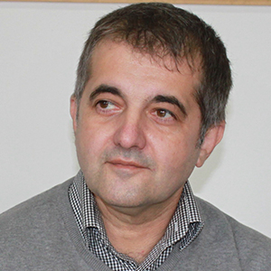
Valentin DANCIU serves as an Associate Professor in the Department of Geodesy and Photogrammetry at the Faculty of Geodesy, University of Architecture and Civil Engineering of Bucharest, where he holds a Doctor of Engineering degree and directs the GEOS Research Center since 2019.
His research spans geodesy, space geodesy, and GNSS implementation, with expertise in spatio-temporal reference systems, coordinate transformations, geoid modeling, and 3D surface analysis. He specializes in processing geodetic measurements, statistical analysis, and integrating satellite/terrestrial technologies for crustal movement studies and infrastructure monitoring. His work focuses on optimizing geodetic networks and advancing applications in navigation, photogrammetry, and GIS across Romania and cross-border regions.
Dr. DANCIU manages the Dunavatu de Jos Laboratory in Tulcea County and leads specialized services including geodetic network design per IGS/EUREF standards, GNSS equipment verification, and calibration protocols. He organizes postgraduate training courses in geodesy and oversees research projects involving structural monitoring for dams, highways, port constructions, and nuclear facilities.
Valentin DANCIU در سایتهای دیگر
جستوجوهای مرتبط
شاید اینها هم برایتان مناسب باشند
 Tiberiu RUSTechnical University of Civil Engineering Bucharest · دانشیار
 Sander VarblaTechnical University of Munich · پژوهشگر
 Cătălina CRISTEATechnical University of Civil Engineering Bucharest · مدرس ارشد
 Andreas WieserETH Zurich · استاد
 Cornel IlincaTechnical University of Civil Engineering Bucharest · مدرس
 Ilinca NăstaseTechnical University of Civil Engineering Bucharest · استاد