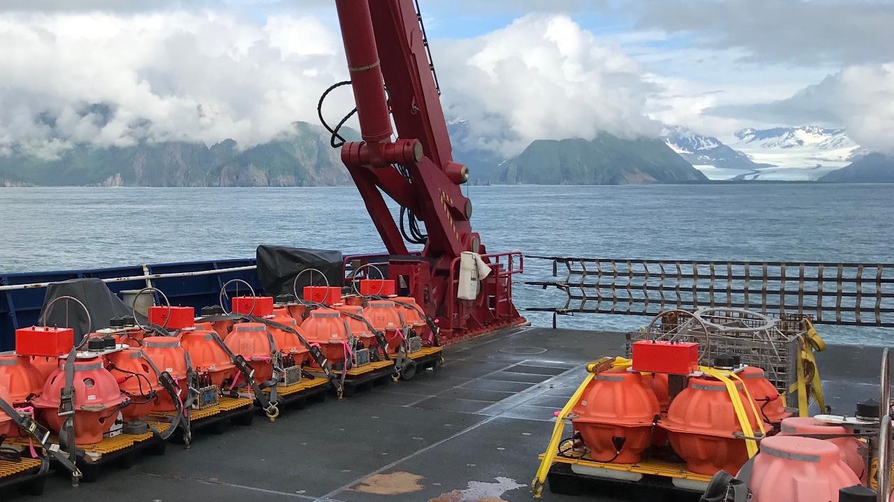
Professor Ana Ferreira is a leading seismologist at University College London, focusing on deep Earth structure and earthquake source processes. Her research integrates seismic and geodetic data to understand planetary dynamics from the surface to the lowermost mantle. Her work includes pioneering seismic tomography, such as the SGLOBE-rani 3D anisotropy model, and earthquake source analysis using InSAR and normal mode data. She leads the Seismological Laboratory and teaches Seismology II and Field Geophysics. Recent projects include the UPFLOW experiment, which deployed 49 ocean bottom seismometers in the Atlantic, and studies on Greenland ice sheet evolution and Tonga volcanic eruptions. Her EU-funded research emphasizes multidisciplinary data integration and numerical modeling. Key article trends cover mantle anisotropy, global tomography, earthquake source inversion, cosmology-inspired machine learning, and ocean bottom seismology applications in geodynamics and cryospheric processes.
Dr Rachel Grant is a Senior Lecturer and Course Director in Bioscience at London South Bank University (LSBU), affiliated with the Bioscience and Bioengineering Research Centre within the School of Human Sciences. She joined LSBU in 2020 after academic roles at Oxford, Cambridge, Anglia Ruskin, and Northampton Universities. Senior Lecturer, LSBU (2020–present) Course Director, Bioscience Research focus: behavioural and evolutionary ecology Her educational background includes: BSc (Hons) Biology (1986–1990) PG Dip Animal Behaviour (2000–2003) PhD (2003–2010) PG Cert LTHE (2012) Rachel's research spans behavioural and evolutionary ecology , with a focus on amphibians, reptiles, and birds. She investigates the influence of geophysical variables on animal behaviour—work relevant to conservation and hazard forecasting. A significant portion of her recent work centers on psittacine bird welfare and personality models, as well as exotic pet welfare models like the Five Domains. She also explores human behavioural ecology , particularly the evolutionary origins of patriarchy and deimatic displays in humans. Her expertise supports the UN Sustainable Development Goals in education and planetary protection. The recent publication trends highlight her interdisciplinary approach, combining zoology, conservation, animal welfare, and evolutionary theory . Her work frequently intersects with public policy, media, and ethical considerations in pet ownership and research inclusivity. Articles from 2024 demonstrate her engagement with both scientific journals and public-facing platforms, addressing topics from reptile expos to disabled researchers' career progression during the pandemic. Scientific engagement and recognition include: Media contributor: Channel 5's "Tsunami", Discovery Channel, NASA Unexplained Files News and radio interviews on animal behaviour and conservation Public engagement through documentaries and outreach Rachel leads curriculum development as Course Director and teaches modules such as Aetiology of Disease, Foundation Biology, Employability, and Level 6 Project. She mentors student research and integrates research methods and statistics into her teaching. While no formal grants or students are listed, her leadership in the DISCOVerY Project indicates involvement in equity-focused research initiatives. She is actively contributing to academic discourse through peer-reviewed publications and public science communication. She is associated with the Bioscience and Bioengineering Research Centre , where her work contributes to understanding animal-environment interactions, improving welfare standards, and promoting inclusive research practices. Her team collaborates on interdisciplinary projects linking biology, geophysics, and social sciences, particularly in risk forecasting and conservation applications.
Professor Jörn Behrens is affiliated with the University of Hamburg at the Climate Campus. He holds the position of Professor and is actively engaged in research related to atmospheric and geophysical modeling. Professor Behrens' research focuses on atmospheric modeling , numerical methods , and geophysical fluid dynamics . His work integrates high-performance computing with advanced mathematical approaches to address complex problems in climate science and natural disaster prediction. He specializes in multiscale modeling techniques that bridge different spatial and temporal scales in atmospheric and geophysical phenomena. Professor Behrens has secured significant research funding through the German Research Foundation (DFG), including: Research grants for "Adaptive modeling of dynamic atmospheric processes on high-performance computers" Priority programs funding for "Interaction of small and large dynamic scales in an adaptive numerical model for atmospheric moist convection" Transregio funding as sub-project manager for "Systematic multiscale modeling and analysis for geophysical currents" Priority programs funding as co-responsible for "KYMA - A multiscale, self-consistent framework for tsunami and earthquake modeling of the Kefalonia Fault System" His work bridges theoretical mathematics with practical applications in climate science and disaster prediction, contributing to both fundamental understanding and real-world solutions for environmental challenges.
Lisa Grant Ludwig is a Professor in the Department of Population Health and Disease Prevention at the University of California, Irvine (UCI). She is a nationally recognized expert in earthquake science, focusing on translating geophysical research into policy for disaster risk reduction. Her work bridges seismology, public health, and policy implementation. PhD in Geology with Geophysics minor (Caltech) MS in Environmental Engineering Science (Caltech) BS in Applied Environmental Earth Science (Stanford) Dr. Ludwig's research centers on earthquake dynamics, particularly along the San Andreas Fault, advancing disaster resilience through innovative nowcasting techniques using AI and machine learning. Her publications demonstrate expertise in seismic hazard modeling, geodetic imaging, and community preparedness studies. Recent publications highlight AI-enhanced earthquake prediction (QuakeGPT), temporal-spatial nowcasting models, and applications of geodetic data for crustal deformation analysis. These works integrate machine learning with traditional seismological methods to improve hazard forecasting. President of Seismological Society of America NASA 2012 Software of the Year Medal Featured on Science magazine cover Congressional Testimony provider Active Federal Advisory Committee member Her interdisciplinary approach combines geophysics, public health policy, and computational science. Current projects focus on earthquake nowcasting, fault zone analysis, and developing accessible geospatial tools like GeoGateway for disaster response.
Joel Johnson is a Professor in the Department of Earth Sciences at the University of New Hampshire. He teaches courses in Earth History, Structural Geology, Sedimentology, Geotectonics, Geological Oceanography, and research-focused classes. With a Ph.D. in Geological Oceanography from Oregon State University and an M.S. in Structural Geology & Tectonics from the University of Illinois at Urbana-Champaign, his research spans gas hydrate systems, sedimentology, and methane cycling in marine environments. Ph.D., Geological Oceanography, Oregon State University M.S., Structural Geology & Tectonics, University of Illinois at Urbana-Champaign B.S., Geology, University of Minnesota Duluth His work examines gas hydrate dynamics in settings like Hydrate Ridge (Cascadia margin) and Svyatogor Ridge (Fram Strait), focusing on crustal processes , fluid flow mechanisms , and authigenic carbonate formation . Studies in the Gulf of Mexico and Indian continental margins analyze hydrate accumulation controls, while Arctic lake research explores methane emission temperature sensitivity and microbial influences . Collaborative projects include 3D seismic analysis , tectonic stress modeling , and monsoon-driven sedimentation in the Bay of Bengal and Andaman Sea. Recent publications highlight earthquake-enhanced carbon cycling in deep sediments (2023), primary deposition controls on gas hydrate reservoirs (2022), and crustal-scale methane systems in Arctic regions (2022). His 15 most recent articles span 2023-2014, emphasizing gas hydrate systems , methane seepage , sedimentary diagenesis , and tectonic influences on fluid flow. Subfields include authigenic carbonate formation , 3D seismic imaging , isotopic geochemistry , and late Quaternary climate reconstructions . Contact: Joel.Johnson@unh.edu
Davin Wallace is an Associate Professor at the University of Southern Mississippi's School of Ocean Science and Engineering, where he investigates coastal and marine system responses to storms, sea-level rise, and sediment dynamics across timescales ranging from days to millennia. His research employs field observations, laboratory analyses, and numerical modeling, with active sites across the Gulf of Mexico, Bermuda, and the Philippines. Education: Ph.D. in Earth Science, Rice University (2007-2010) B.S. in Geology and German, Tulane University (2003-2006) Research Focus: Dr. Wallace's work bridges paleotempestology, coastal geomorphology, and sedimentary processes. His research examines hurricane impacts on sediment structures, barrier island resilience under sea-level rise, and Holocene coastal evolution. He specializes in reconstructing historical storm patterns using geologic proxies and assessing anthropogenic influences on coastal erosion. Publication Trends: His recent articles demonstrate interdisciplinary approaches to coastal vulnerability, combining geophysical data, machine learning, and multiproxy sediment analysis. Work consistently addresses climate change impacts, with emphasis on sedimentation mechanisms during extreme events and Quaternary landscape evolution. Scientific Recognition: No major awards documented in provided sources. Academic Leadership: Leads the USM Coastal Evolution and Hazards Research Lab, supervising field campaigns and collaborative projects. Secured grants for Gulf Coast studies from NSF and NOAA. Mentors graduate students in geological oceanography programs and coordinates international research teams across field sites.
Walter Szeliga is a Professor and Department Chair at Central Washington University. He holds a Ph.D. from the University of Colorado (2010). His research focuses on seismology, GPS, and InSAR technologies, with emphasis on earthquake early warning systems, crustal deformation monitoring, and natural hazards mitigation. Dr. Szeliga leads efforts in integrating real-time geodetic data streams for disaster response and has contributed to the development of ShakeAlert® systems. His work spans global geophysical networks, ionospheric perturbations, and paleotsunami studies. Key research interests include: Real-time GNSS applications for seismic monitoring Crustal deformation analysis using InSAR and GPS Earthquake source characterization through multi-method approaches Historical seismotectonic reconstructions Disaster forecasting and early warning system optimization Recent studies highlight advancements in trapping atmospheric lee waves detection via GNSS, volcanic plume dynamics during the 2022 Tonga eruption, and long-term paleotsunami records in Chile. His work bridges geophysical instrumentation with computational modeling to address critical questions in tectonic processes and hazard assessment. Scientific contributions include 50+ peer-reviewed articles on topics ranging from Cascadia subduction zone dynamics to global navigation satellite system innovations. His research has implications for civil infrastructure resilience, space weather impacts, and international geohazard collaboration frameworks.
Kyle Bradley is a research-focused academic affiliated with the College of Engineering at Cornell University, specifically within the Department of Earth and Atmospheric Sciences. His work centers on active tectonics, earthquake geology, and geodetic modeling, with extensive fieldwork and satellite-based analysis in Southeast Asia, particularly Indonesia and Myanmar. University: Cornell University School: College of Engineering Department: Department of Earth and Atmospheric Sciences Academic Rank: Research Professor His research interests lie primarily in understanding the mechanics of active fault systems, subduction zones, and their associated hazards. He investigates how tectonic and volcanic processes interact, particularly in regions like the Flores Thrust and Sumatran Fault Zone. His methodologies include GPS and InSAR geodesy, photogrammetry, drone-based mapping, and seismic source modeling to constrain fault geometries, slip rates, and rupture behaviors. The trends in his recent publications indicate a strong emphasis on interdisciplinary geophysics, combining structural geology, seismology, and geochemistry to assess seismic and tsunami hazards. His work often integrates high-resolution geospatial data with field observations to develop models of crustal deformation and earthquake cycles. Although no formal scientific awards are listed in the provided content, his consistent publication record in high-impact journals reflects significant scholarly contributions. There is no mention of formal grant funding, but his research scope suggests involvement in federally or institutionally supported projects. Kyle Bradley has not listed any students in the provided information, but his role as a research professor implies potential mentorship of graduate students and postdoctoral researchers. His work contributes to understanding earthquake triggering mechanisms, such as the role of wet rice cultivation in landslides during the 2018 Palu earthquake, demonstrating applied relevance to disaster risk reduction. He is actively involved in developing regional tectonic models using dense GNSS networks, focal mechanism catalogs, and bathymetric data. His research teams likely include collaborators from international institutions, particularly in Indonesia and Southeast Asia, given the geographic focus of his studies. Labs or research groups associated with his work may utilize geospatial analysis, satellite remote sensing, and computational modeling of tectonic processes.
Alison Raby is Professor of Environmental Fluid Mechanics and Head of the COAST Engineering Research Group at University of Plymouth. Specializing in wave-structure interactions, she leads research on coastal resilience and tsunami impacts. Her STORMLAMP project examined wave loading on rock lighthouses. Research focuses on: Extreme wave impacts on coastal structures Tsunami debris transport and flooding Climate change adaptation for coastal communities Compound flooding modeling Honored as a 2021 Engineering Hero by the Women's Engineering Society, Dr. Raby directs NERC-funded projects including C-FLOOD investigating compound flooding in Sri Lanka. She utilizes Plymouth's COAST laboratory for physical modeling of wave impacts. Key Projects: STORMLAMP: Structural behavior of rock lighthouses C-FLOOD: Compound flooding from cyclones in Sri Lanka SENSUM: Smart sensor networks for natural hazards
Gaofeng Jia is Associate Professor in Civil and Environmental Engineering at Colorado State University's Walter Scott, Jr. College of Engineering. He specializes in natural hazard risk assessment, infrastructure resilience, and uncertainty quantification. Research integrates simulation-based approaches with high-performance computing for assessing complex engineering systems. Core areas include infrastructure deterioration modeling, wave energy converter optimization, tsunami evacuation planning, and surrogate modeling techniques. Recent work emphasizes physics-informed machine learning for engineering applications. Publications demonstrate consistent methodological innovation in uncertainty quantification across domains including seismic engineering, coastal hazards, renewable energy systems, and structural reliability. Articles employ advanced computational statistics, Bayesian methods, and multi-fidelity modeling. Young Researcher Best Paper Award Best Student Paper Award
Professor Daniel Fitzpatrick is an Adjunct Professor at the Faculty of Law, Monash University. Previously, he served at the Australian National University (ANU) as Director of the Centre for Commercial Law and established the Masters in Law, Governance and Development. He has held visiting roles globally, including at New York University School of Law, National University of Singapore, University of Muenster, and University of Toronto. In 2022, he was a Scholar-in-Residence at the Woodrow Wilson Institute for International Scholars. His research focuses on property rights in disaster and climate-affected contexts, contributing to UN Sustainable Development Goals. Key areas include land tenure systems in fragile states, climate mobility governance, and adaptive legal frameworks for environmental displacement. He has authored or co-authored 6 books and published in leading journals such as the Yale Law Journal and American Journal of Comparative Law. With over A$1,031,690 in ARC funding since 2012, Fitzpatrick’s work addresses property resilience in Indonesia, the Solomon Islands, and other disaster-prone regions. He advises international organizations like the World Bank on land policies for disaster risk management and climate mobility. His expertise also includes post-conflict land policy, having served as the UN’s land rights adviser in East Timor and Aceh, and as a consultant for Oxfam, OECD, and UN agencies. Fitzpatrick has been recognized with the Hart Article Prize (2007) and Australian Research Council Future Fellowship (2012–2016). His teaching excellence was acknowledged through nominations at ANU (2010–2011). Current affiliations include the expert advisory committee for the Platform on Disaster Displacement and collaborative projects with the Pacific Islands Forum Secretariat.
Agata Di Stefano is a Full Professor of Stratigraphic Geology and Sedimentology (GEO/02) at the University of Catania, where she has held academic positions since 2002. She currently serves as President of the Bachelor's Degree Course in Geological Sciences (L-34) and Head of the Marine Geology Laboratory. Her academic journey includes roles as PhD Coordinator for Earth and Environmental Sciences (2017-2023) and prior leadership in the Department of Biological, Geological and Environmental Sciences’ Erasmus initiatives. PhD in Geological Evolution of Mediterranean-Type Orogens (1993) Professional Geologist certification (1990) University of Catania faculty member since 2002 Her research focuses on bio-chronostratigraphic analysis , paleoclimatic modeling , and coastal environmental protection , with emphasis on Mediterranean and oceanic Neogene-Quaternary sequences. She has contributed to international ocean drilling projects (ODP/IODP) and polar sediment studies (ANDRILL), while leading geological cartography under the CARG project. Key projects include: National Coordinator, MIUR-PRIN 2022 'Timing of Early Pleistocene Climate Transitions' Scientific Director, Interreg V SIMIT_THARSY Tsunami Hazard Reduction System Lead Partner, Interreg VI SANDLAND coastal sediment protection Awards: 2013 'Feature Article' in 'Ocean & Coastal Management' 1994 Young Researchers Award (Earth Sciences) from Gioenia Academy As an educator, she teaches 'Stratigraphic Geology', 'Marine Geology', and 'Innovative Methods in Marine Geology', supervising over 88 theses across all academic levels. She serves on editorial boards for the Italian Journal of Geological Science and International Journal of Geoscience , and collaborates with institutions like CNR, INGV, and international universities.
Hermann M. Fritz is a full Professor at the Georgia Institute of Technology within the College of Engineering's School of Civil and Environmental Engineering. With expertise spanning tsunamis, coastal hazards, hurricane storm surges, landslides, and submarine volcanic eruptions, his research focuses on the fluid dynamics aspects of these natural hazards and their mitigation strategies. Dr. Fritz earned his Doctorate degree (Dr. sc. ETH Zurich) in 2002 from the Swiss Federal Institute of Technology in Zurich. His extensive field experience includes leading or participating in more than a dozen post-disaster reconnaissance campaigns across multiple continents, documenting tsunami events from the 2004 Indian Ocean tsunami through the 2017 Greenland event, and hurricane surveys from Hurricane Katrina (2005) to Hurricane Nate (2017). His research integrates physical modeling with field observations, with recent work focusing on tsunamis generated by submarine volcanic eruptions, as evidenced by his development of a unique volcanic tsunami generator for large-scale wave basin experiments. His publication record shows consistent high-impact research in natural hazard science, with a particular emphasis on understanding wave generation mechanisms, coastal inundation patterns, and sediment transport processes during extreme events. Among his notable recognitions is the Plinius Medal from the European Geosciences Union (2014), highlighting his significant contributions to natural hazard research. His work bridges fundamental fluid dynamics with practical applications for coastal protection and disaster risk reduction. Plinius Medal, EGU (European Geosciences Union) - 2014 Dr. Fritz has mentored numerous students through his research projects, though specific names aren't provided in the available information. His collaborative approach is evident through his extensive co-authorship network spanning multiple institutions worldwide. Current research directions include advanced physical modeling of tsunami generation mechanisms, particularly those related to volcanic activity and landslides, as well as improving coastal resilience against extreme events. His laboratory work at Georgia Tech involves sophisticated experimental setups including large three-dimensional wave basins and specialized generators for simulating complex natural phenomena under controlled conditions. This experimental approach complements his extensive field survey experience, creating a powerful research methodology that connects theoretical understanding with real-world observations.
Anne Sheehan is Professor of Geological Sciences at the University of Colorado Boulder and a Fellow of the Cooperative Institute for Research in Environmental Sciences (CIRES). Her research integrates seismology, geodesy and electromagnetics to investigate earthquake sources, subduction-zone dynamics, tsunami generation and human-induced seismicity. Education Ph.D., Massachusetts Institute of Technology, 1991 B.S., University of Kansas, 1984 Research Interests Sheehan’s group pursues field and computational studies of earthquake seismology , tsunami processes , active tectonics and geophysical imaging . Major themes include: Deep structure and tectonics of mountain belts (Rockies, Himalaya, Southern Alps) Subduction-zone seismicity, slow-slip events and tsunami hazards Induced seismicity linked to wastewater injection in Colorado Novel seafloor instrumentation (ocean-bottom seismometers, pressure gauges) and satellite-based tsunami detection from ships Advanced computational techniques such as data assimilation, interferometry and machine-learning phase detection Scientific Awards Erasmus Haworth Distinguished Alumni Award, University of Kansas (2009) EarthScope Distinguished Lecturer (2013) College Scholar Award, University of Colorado (2014) New Zealand Geophysics Prize (2016, 2019) President, Seismology Section, American Geophysical Union (2020) Leadership, Grants & Teams Sheehan is Principal Investigator on major NSF experiments such as the Alaska Amphibious Community Seismic Experiment (AACSE) and the Hikurangi Ocean Bottom Investigation of Tremor and Slow Slip (HOBITSS) . She collaborates closely with the hydrogeology group of Prof. Shemin Ge and geodesist Prof. Kristy Tiampo, and mentors graduate students and post-docs in the Sheehan Geophysics Group . The group maintains real-time seismic data access for Colorado at earthquake.colorado.edu and hosts weekly seminars and reading groups.
Sara Barsotti is a researcher at the National Institute of Geophysics and Volcanology (INGV) specializing in volcanology and volcanic hazard assessment. Her key roles include: Associate Editor for Volcanology at Frontiers in Earth Science Review Editor for Geohazards and Georisks at Frontiers in Earth Science Contributor to the EU Center of Excellence for Exascale in Solid Earth (ChEESE) Member of the EUROVOLC citizen-science initiative Collaborator with European volcano observatories Her research focuses on computational geophysics, volcanic hazard modeling, and operational monitoring systems. She investigates tephra dispersion dynamics, lava flow behavior, and probabilistic hazard assessment using high-performance computing. Her work emphasizes European volcanic systems—particularly Icelandic eruptions—and integrates multidisciplinary approaches to improve crisis management protocols and public safety during volcanic events. Analysis of her recent publications reveals a strong trend toward operationalizing advanced computational methods for real-time hazard assessment. Key developments include exascale computing applications for solid earth simulations, refinement of the Aviation Colour Code system for aviation safety, and citizen-science data integration for eruption monitoring. These efforts consistently target practical risk mitigation strategies during active volcanic crises like the 2021 Fagradalsfjall eruption. Scientific awards: None mentioned in the provided text. While specific advised students or individual grants aren't documented, her leadership in major European projects (ChEESE, EUROVOLC) demonstrates substantial involvement in funded research initiatives. These projects coordinate transnational collaborations involving observatories, research centers, and emergency management agencies across Europe. Barsotti actively participates in integrated European volcano infrastructure teams, contributing to standardized monitoring protocols, hazard communication frameworks, and crisis response systems. Her work bridges institutional observatories (e.g., Icelandic Meteorological Office, INGV sections) with community-based monitoring tools, enhancing data collection and public engagement during volcanic unrest.