
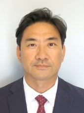
About
Dr. Jae Sung Kim is an Assistant Professor in the Department of Civil, Environmental, and Geospatial Engineering at Michigan Technological University (MTU). He holds a PhD in Geomatics from Purdue University and teaches courses in photogrammetry, UAV mapping, and geospatial technology. His research focuses on geospatial technologies, including remote sensing, GIS, and their applications in agriculture, environmental science, and planetary studies.
- PhD: Geomatics, Purdue University
- MSCE: Civil Engineering, Purdue University
- ME: Civil Engineering, Korea University
- BE: Civil Engineering, Korea University
Dr. Kim’s research interests span photogrammetry, remote sensing, geodesy, and geospatial cyberinfrastructure. He develops tools for agricultural water management (FARMs system) and landslide analysis. His work often utilizes open-source geospatial technologies and integrates historical aerial photography with modern GIS systems.
His recent publications include studies on volcanic lava flow modeling (2025), winter vegetation detection via remote sensing (2024), and automated orthorectification of archival aerial photos (2022). These reflect his expertise in combining traditional geospatial methods with cutting-edge technologies.
Dr. Kim serves as an Associate Editor for the Journal of Applied Remote Sensing and Assistant Director of the Photogrammetric Applications Division at ASPRS. He has also contributed to watershed delineation tools and web-based water monitoring systems using open-source frameworks.
Find Jae Sung Kim elsewhere
Related Searches
You Might Also Like
 Eugene LevinMichigan Technological University · Adjunct Associate Professor
- HHeather PapworthBournemouth University · Researcher
- AAnna Fryśkowska-SkibniewskaMilitary University of Technology · Assistant Professor
 Christopher ParrishOregon State University · Professor
 Yushin AhnCalifornia State University, Fresno · Associate Professor
 Jeffery Pereira HollingsworthMichigan Technological University · Professor